| 論文篇名 | 英文:Post-earthquake spatio-temporal landslide analysis of Huisun Experimental Forest Station 中文:惠蓀林場震後崩塌時空變化分析 |
| 期刊名稱 | TERRESTRIAL, ATMOSPHERIC AND OCEANIC SCIENCES JOURNAL |
| 發表年份,卷數,起迄頁數 | 2019,30(4),493-508 |
| 作者 | Yang, Ming-Der (楊明德); Tsai, Hui-Ping (蔡慧萍)* |
| DOI | 10.3319/TAO.2019.03.03.01 |
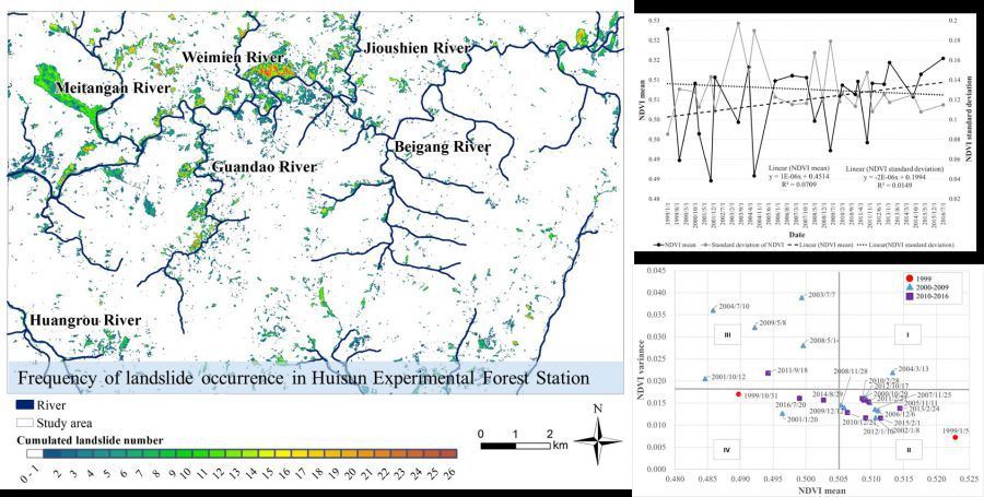
| 中文摘要 | 本研究利用1999年至2016年間共26張SPOT衛星影像和常態化差異植被指數(Normalized Difference Vegetation Index, NDVI),進行惠蓀林場(Huisun Experimental Forest Station, HEFS)於集集地震後崩塌的時空變化分析。透過線性回歸(Linear regression)和平均方差(Maean-Variance analysis)分析,HEFS總崩塌面積於地震後波動很大,但於2008年之後趨於穩定,NDVI平均值略有增加且方差值降低。新生村和美湯岸溪沿岸的兩個大型崩塌區為具有統計意義的崩塌熱點。超過50%的崩塌發生於南向和東南向坡,其中大多數的崩塌發生在高度500-1500 m之間。分析發生崩塌地點的坡度特徵,在集集地震後集中於30-40度之間,而在2008年之後集中於20-30度之間。分析崩塌的發生頻率,發現0-9次的頻率區間總崩塌面積最大;在0-9次和17-26次的頻率區間中,較多比例的崩塌都發生在南向坡與東南向坡。另外在空間分析中,發現距離河道越近,崩塌發生越多,這樣的情形在崩塌發生頻率中0-9次以及10-16次的頻率區間最為明顯。此惠蓀林場的崩塌時空變化分析結果,可提供未來林場管理和擬定水土環境保護策略之參考。 |
| 英文摘要 | The present study utilized satellite imagery and the Normalized Difference Vegetation Index (NDVI) to investigate the post-earthquake spatio-temporal changes of landslide for Huisun Experimental Forest Station (HEFS). Total 26 SPOT satellite images taken between January 1999 (before the Chi-Chi earthquake) and July 2016 shows that the total landslide area was fluctuated after the earthquake and then became stable after 2008. Overall, the long-term landslide trends of HEFS is approaching a stable stage in terms of the slightly increasing mean NDVI value with decreasing NDVI variance from 1999 to 2016 based on the linear regression and Mean-Variance analyses. Two large landslide areas in Xinsheng Village and along Meitangan River were identified as statistically significant hot spots. More than 50% of landslides in HEFS were observed in areas with S-facing and SE-facing slopes with the majority of landslides occurred at 500 - 1500 m elevation. The slope characteristic of landslides changed to a concentration in 30 - 40 degree after the Chi-Chi earthquake and changed again to a concentration in 20 - 30 degree after 2008. Based on the results of the frequency of landslide occurrence, the total landslide area was the largest in the 0 - 9 times category. In the 10 - 16 and 17 - 26 times categories, high percentages of landslides were found in SE-facing and S-facing slopes. An inverse relationship was found between the landslide areas and the distance to river channel in the 0 – 9 and 10 - 16 times categories. The results of spatio-temporal landslide analysis can be references for management and conservation strategies in HEFS. |
Post-earthquake spatio-temporal landslide analysis of Huisun Experimental Forest Station 2019-03-03

生態農業:農業地景生態監測及復育【土木系楊明德教授、蔡慧萍助理教授】


