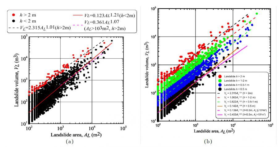
| 論文篇名 | 英文:Exploring landslide erosion volume–area scaling relationships by slip depth using changes in DTMs for basin sediment volume estimation 中文:利用崩塌深度中DTM的變化探討探討侵蝕體積與面積的關係以推估流域內的沉積物含量 |
| 期刊名稱 | Springer |
| 發表年份,卷數,起迄頁數 | 2019,16,581~594 |
| 作者 | Su-chin Chen, Chien-yuan Chen* and Wen-yan Huang |
| DOI | 10.1007/s11629-018-4888-3 |
| 中文摘要 | 崩塌會產生大量的沉積物,並降低了水庫的壽命。本研究調查了台灣石門水庫流域在2008年由辛樂克颱風和薔蜜颱風所引發的崩塌。研究中建立了崩塌體積與面積間的比例關係並藉此推估崩塌的泥沙變化量。研究方法中分別建立崩塌事件發生前後的數值高程模型(5m x 5m),藉由地理資訊系統(GIS)進行空間分析,透過比對崩塌事件發生前後的數值高程模型(DTM)變化量來量測侵蝕的體積及面積。統計分析結果表明,崩塌頻率與規模呈現冪律分布,崩塌頻率與面積的標度指數為2.15,而崩塌頻率與體積的標度指數則為1.66。本研究也根據不同的崩塌深度與崩塌體積提出了不同的比例關係,以避免體積估算中的誤差。在崩塌深度小於2公尺的崩塌中,其標度指數為1.21;而崩塌深度大於2公尺的崩塌,其標度指數為1.01。本研究所提出的崩塌深度與崩塌體積的比例關係是實用的,它可為水庫流域的泥沙預算規劃提供初步的結果。 |
| 英文摘要 | Landslides produce large quantities of sediment deposits and reduce reservoir life. This study investigated landslides at the Shihmen Reservoir basin in Taiwan that were induced by Typhoon Sinlaku and Typhoon Jangmi in 2008. We formulate scaling relationships between landslide erosion volume and area and conclude that sediment budget can be estimated based on the easier to determine landslide erosion area. The methodologies applied for the investigation were geomorphological analysis through 5 m × 5 m digital terrain models (DTMs) of the basin created before and after the landslide events and spatial analysis through a geographic information system. The erosion area and volume of landslides were measured through the subtraction of DTMs produced before and after the events. Statistical analysis revealed that the landslide erosion frequency–magnitude distribution exhibited power-law behaviors with a scaling exponent of 2.15 for the frequency–area distribution and 1.66 for the frequency–volume distribution. This paper proposes different scaling relationships for different moving depths, and landslide erosion volumes were estimated on the basis of depth; thus, landslides of different scales can be distinguished to avoid errors in volume estimation. Two different scaling exponents are proposed: 1.21 for landslide erosions with depths of less than 2 m and 1.01 for landslide erosions with depths of more than 2 m. The proposed scaling relationships are practical for landslide erosion volume estimation by different depths according to the landslide area, and they can provide preliminary results for sediment budget planning in a reservoir basin. |
Exploring landslide erosion volume–area scaling relationships by slip depth using changes in DTMs for basin sediment volume estimation 2019-02-21

生態農業:農業地景生態監測及復育【水保系陳樹群特聘教授】


