生態農業:農業精準栽培管理技術開發【土壤環境科學系申雍教授】
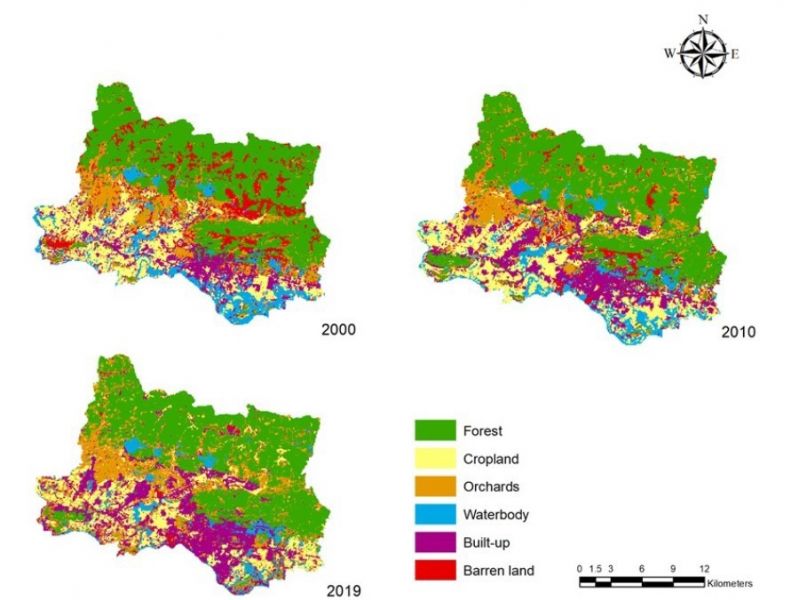
| 論文篇名 | 英文:Land-use and land-cover changes in DongTrieu district, Vietnam, during past two decades and their driving forces 中文:過去 20 年越南 DongTrieu 區土地利用和土地覆蓋變化及驅動力 |
| 期刊名稱 | Land |
| 發表年份,卷數,起迄頁數 | 2021, 10, no.798 |
| 作者 | Vu, Thi-Thu(武氏秋); Shen, Yuan(申雍)* |
| DOI | 10.3390/land10080798 |
| 中文摘要 | 土地利用和土地覆蓋 (LULC) 的變遷分析有助於了解我們生活環境的變化及其驅動因素。通過分析過去 LULC 變化趨勢得出的驅動因素,可提供做為評估和 定位當前和未來的土地利用政策使用。作為越南廣寧省的入口,Dong Trieu 地區在過去的二十年中經歷了顯著的 LULC 變化。本研究通過最大似然技術從 Landsat 影像中獲得了 2000 年、2010 年和 2019 年 Dong Trieu 區 6 個一級 LULC 分類(森林、農田、果園、水體、建成區和荒地)的空間分佈。過去 20 年觀察 到的最顯著變化是荒地減少 (9.1%)以及建成區 (8.1%) 和果園 (6.8%) 增加。驅動因子分析表明,耕地和建成區的變化取決於距道路的距離(DFR)、距主幹 道的距離(DFMR)、距城市的距離(DFU)、距水面的距離(DFW)、海拔、坡度和人口密度。森林的變化取決於除了 DFMR 外的所有驅動力。果園主 要出現在人口密集區附近。水體的轉化受地理(海拔和坡度)和人口密度的影響。人口密度越高,土地就越不貧瘠。 |
| 英文摘要 | Land-use and land-cover (LULC) change analyses are useful in understanding the changes in our living environments and their driving factors. Modeling changes of LULC in the future, together with the driving factors derived through analyzing the trends of past LULC changes, bring the opportunity to assess and orientate the current and future land-use policies. As the entryway of Quang Ninh province, Vietnam, Dong Trieu locale has experienced significant LULC changes during the past two decades. In this study, the spatial distribution of six Level I LULC classes, forest, cropland, orchards, waterbody, built-up, and barren land, in Dong Trieu district at 2000, 2010, and 2019 were obtained from Landsat imageries by maximum likelihood technique. The most significant changes observed over the past twenty years are a decrease of barren land (9.1%) and increases of built-up (8.1%) and orchards (6.8%). Driving factor analysis indicated that the changes of cropland and built-up were dependent on distance from road (DFR), distance from main road (DFMR), distance from urban (DFU), distance from water (DFW), elevation, slope, and population density. The changes of forest were dependent on all the driving forces listed above, except DFMR. The orchards mainly appeared near the high-population-density area. The transformation of the waterbody was affected by geography (elevation and slope) and population density. The higher the population density, the less barren the land would appear. |
| 發表成果與本中心研究主題相關性 | 本研究通過對土地利用和土地覆蓋的變遷分析,瞭解導致土地利用和土地覆蓋變化的驅動因素,可提供做為評估和定位越南當前和未來的土地利用政策使 用,進而促成國土的永續發展利用。 |


