生態農業:農業地景生態監測及復育【土木工程學系/楊明德特聘教授、蔡慧萍助理教授】
| 論文篇名 | 英文:Semantic Segmentation Using Deep Learning with Vegetation Indices for Rice Lodging Identification in Multi-date UAV Visible Images 中文:基於深度學習和植被指數的語義分割於多時期無人機可見光影像中之水稻倒伏辨識 |
| 期刊名稱 | REMOTE SENSING |
| 發表年份,卷數,起迄頁數 | 2020, 12 (4),633 |
| 作者 | Yang, Ming-Der (楊明德); Tseng, Hsin-Hung; Hsu, Yu-Chun; Tsai, Hui Ping (蔡慧萍)* |
| DOI | 10.3390/rs12040633 |
| 中文摘要 | 快速而精確的大規模農業災難調查是農業災難救濟和保險的基礎,但需耗費大量人力且時間。本研究透過深度學習之影像處理將無人飛行器(UAV)影像應用於大面積稻田倒伏估計。這項研究使用兩種神經網絡體系結構FCN-AlexNet和SegNet的影像語義分割模型,並針對影像大小和計算效率做比較。利用商用無人機取得高解析度可見光稻田影像,用於計算三個植生指標,以提高可見光影像的適用性。本研究所提出的模型對一組2017年無人機影像進行了訓練和測試,並對一組2019年無人機影像進行驗證。在2017年無人機影像的水稻倒伏辨識表現上,FCN-AlexNet和SegNet的F1得分分別為0.80和0.79。使用RGB + ExGR組合的FCN-AlexNet的F1分數在2019年影像驗證測試中也達0.78,與禪統最大概似法相比,本研究所提出的語義分割網絡模型具有更高的效率,約10至15倍的速度,以及較低的誤辨率。 |
| 英文摘要 | A rapid and precise large-scale agricultural disaster survey is a basis for agricultural disaster relief and insurance but is labor-intensive and time-consuming. This study applies Unmanned Aerial Vehicles (UAVs) images through deep-learning image processing to estimate the rice lodging in paddies over a large area. This study establishes an image semantic segmentation model employing two neural network architectures, FCN-AlexNet, and SegNet, whose effects are explored in the interpretation of various object sizes and computation efficiency. Commercial UAVs imaging rice paddies in high-resolution visible images are used to calculate three vegetation indicators to improve the applicability of visible images. The proposed model was trained and tested on a set of UAV images in 2017 and was validated on a set of UAV images in 2019. For the identification of rice lodging on the 2017 UAV images, the F1-score reaches 0.80 and 0.79 for FCN-AlexNet and SegNet, respectively. The F1-score of FCN-AlexNet using RGB + ExGR combination also reaches 0.78 in the 2019 images for validation. The proposed model adopting semantic segmentation networks is proven to have better efficiency, approximately 10 to 15 times faster, and a lower misinterpretation rate than that of the maximum likelihood method. |
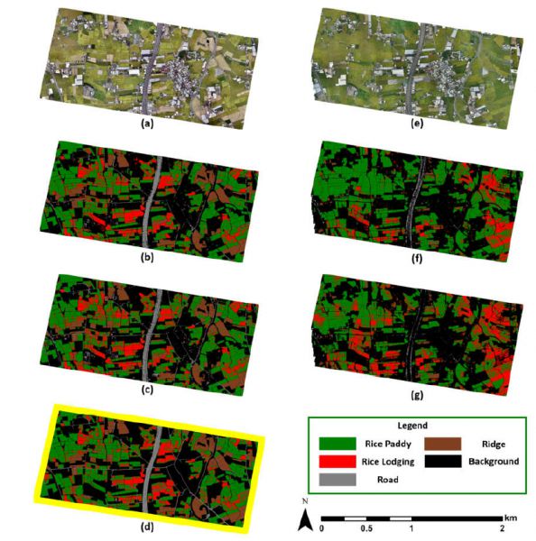
Figure. Results of identification on the total 230 ha. area by the best performance models: (a) 2017 dataset orthoimage, (b) 2017 dataset prediction of FCN-AlexNet using RGB+ExGR information, (c) 2017 dataset prediction of SegNet using RGB+ExGR, (d) ground truth, (e) 2019 dataset orthoimage, (f) 2019 dataset prediction of FCN-AlexNet using RGB+ExGR information, (g) 2019 dataset prediction of SegNet using RGB+ExGR.

