生態農業:自然解方修復極端氣候退化坡地之生態地景【水土保持學系/陳樹群特聘教授】
| 論文篇名 | 英文:Stream power curve-loop-spiral conceptual method and an application to rivers of Taiwan |
| 期刊名稱 | Journal of Hydrology: Regional Studies |
| 發表年份,卷數,起迄頁數 | 2023,48,101472 |
| 作者 | Chen, Su-Chin(陳樹群); Tsai, Jui-Tien; Chen, Yi-Chin; Tsai, Fu-Hsuan; Liang, Chia-Yin; Chiu, Yen-Yu* |
| DOI | 10.1016/j.ejrh.2023.101472 |
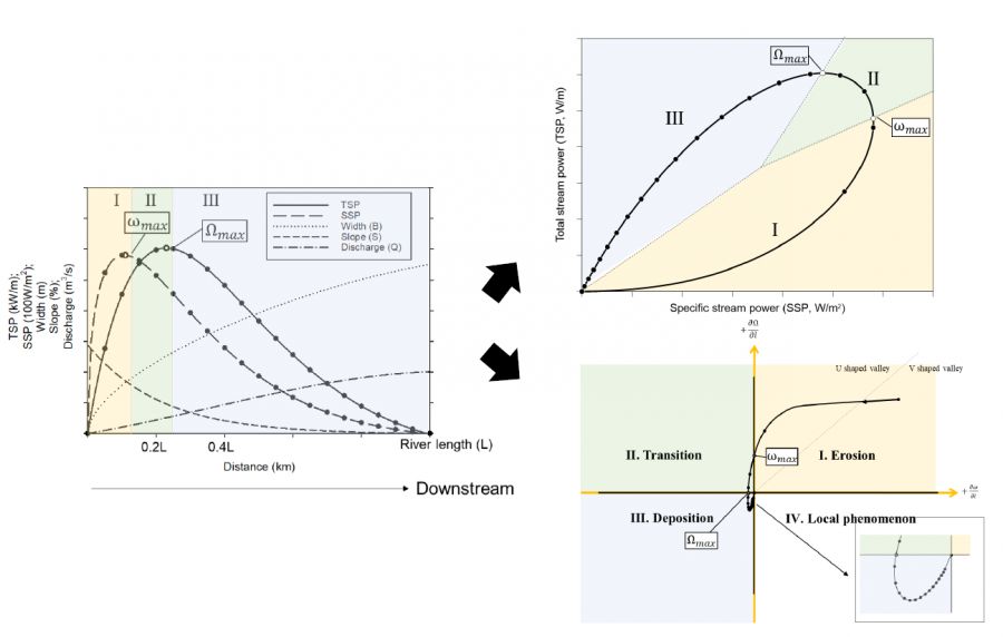
| 中文摘要 | 總河流功率(TSP)或單位河流功率(SSP)是用於評估渠道狀態的指標。本文提出了一個新的名為“河流功率迴圈”的概念圖,用於回顧從河流源頭到河口的河流條件、形態和沉積物輸送潛力的變化。這個理想迴圈用於開發河流功率曲線-迴圈-螺旋方法。理論迴圈假設河流的流量和河道坡度延河流縱剖面分別持續增加和減少,並形成河流中TSP和SSP的連續變化趨勢。由於它有物理基礎,迴圈可反映河流的形態和流域的環境條件。我們還利用個螺旋圖描繪了TSP和SSP的空間梯度的變化。這個梯度暗示了沉積物輸送趨勢,在理想條件下,它從上游到下游逐漸從沖刷變為淤積。迴圈和螺旋圖概述了河流系統的形態和沉積物輸送潛力。 18條臺灣河川用於驗證迴圈的應用,可以分為三種類型:簡單迴圈、楓葉迴圈和複雜迴圈。7條河川因環境條件相對簡單而形成簡單迴圈。有十條河川形成楓葉迴圈,歸因於岩性的複雜性。還有一條河川因極端的沉積災害而形成複雜迴圈。而地質條件是這三種類型之間差異的原因。多樣的地質增加了大型支流和地形急劇變化的可能性,這兩者都會影響河流功率的組成部分。從18條河川收集到的所有資料的散佈分佈支援了理論的螺旋圖。它顯示了從河流源頭到河口的收縮半徑和逆時針螺旋路徑,經過山地河區,編織河區,最終到達直流和蜿蜒河區。 |
| 英文摘要 | The concept of total stream power (TSP) or specific stream power (SSP) has been investigated previously as an index for assessing the status of a river channel. Here we introduce a new diagram called the “stream power loop” to review variations in fluvial conditions, morphology, and sediment transport potential from river source to estuary. The diagram of the ideal loop is used to develop the stream power curve–loop–spiral method. The ideal loop assumes that river discharge and channel slope along with the longitudinal profile of the river respectively increase and decrease continuously, and it forms the contiguous variation trends in TSP and SSP along the river. Because of its physical basis, the loop diagram reflects river morphology and watershed environmental conditions. In addition, we present a spiral diagram that depicts variations of the spatial gradients in TSP and SSP. The gradient implied the sediment transport trend, which from upstream to downstream changes gradually from scouring to siltation in ideal conditions. The loop and spiral diagrams overview of the morphology and sediment transport potential of the fluvial system. Eighteen rivers in Taiwan demonstrate the application of the loop diagram that can be categorized into three types: simple loop, maple-leaf loop, and complex loop. Seven rivers with more uncomplicated environmental conditions form simple loops, similar to the ideal loop. Ten rivers form maple-leaf loops, attributing to the lithological complexity. And one river forms a complex loop because of the extreme sediment disasters. Geological conditions are the underlying cause of the differences between the three types. Diverse geology increases the likelihood of large tributaries and abrupt changes in terrain, both of which affect the components of stream power. The scatter distribution of all the data aggregated from the 18 rivers supports the ideal spiral diagram. It shows a shrinking radius and counter-clockwise spiral pathway from river source to estuary, with passage through the mountain river zone, the braided river zone, and finally to the straight & meandering river zone. |
| 發表成果與本中心研究主題相關性 | 說明了溪流的理想狀態與沖淤趨勢。 |