生態農業:農業地景生態監測及復育【土木工程學系/楊明德特聘教授】
| 論文篇名 | 英文:Quantifying Flood Water Levels Using Image-Based Volunteered Geographic Information 中文:使用影像自願地理資訊量化洪水水位 |
| 期刊名稱 | REMOTE SENSING |
| 發表年份,卷數,起迄頁數 | 2020, 12 (4),706 |
| 作者 | Lin, Yan-Ting; Yang, Ming-Der(楊明德)*; Han, Jen-Yu; Su, Yuan-Fong; Jang, Jiun-Huei |
| DOI | 10.3390/rs12040706 |
| 中文摘要 | 許多人使用智慧手機捕獲影像記錄生活環境,並在社交網絡(如Facebook,Instagram和Twitter)上分享日常生活的各個方面。這些平台提供了自願的地理信息(VGI),使公眾能夠知道事件發生的時間和地點。同時,基於影像的VGI還可以指示環境變化和災難情況,例如洪水範圍和相對水位。但是,由於很難識影像VGI中的水線並將其鏈接到詳細的地形模型,因此基於影像的VGI幾乎沒有用於量化洪水水位。本研究提出數位影像處理和攝影測量方法來確定水位,透過智慧手機相機獲得影像VGI以實現了洪水檢測。在數位影像處理中,應用隨機森林分類來簡化環境複雜度並突出淹水區域,並且使用HT-Canny方法檢測基於已分類影像的洪線。透過攝影測量和無人飛行器製圖技術的數位高程模型,可檢測洪水線、量化水位。影像VGI之水位檢測實驗於台北市一城市洪水事件,使用隨機森林之監督式分類產生的分類影像總共為三個類別,平均總體準確度為88.05%。量化的水位分解析度為公分(平均差異小於3公分),可以做為驗證洪水模擬,並可從點觀測擴展到面狀評估,大幅改進了影像VGI可量化的有限性,可為災害管理機構提供了可靠而有效的洪水監控技術。 |
| 英文摘要 | Many people use smartphone cameras to record their living environments through captured images, and share aspects of their daily lives on social networks, such as Facebook, Instagram, and Twitter. These platforms provide volunteered geographic information (VGI), which enables the public to know where and when events occur. At the same time, image-based VGI can also indicate environmental changes and disaster conditions, such as flooding ranges and relative water levels. However, little image-based VGI has been applied for the quantification of flooding water levels because of the difficulty of identifying water lines in image-based VGI and linking them to detailed terrain models. In this study, flood detection has been achieved through image-based VGI obtained by smartphone cameras. Digital image processing and a photogrammetric method were presented to determine the water levels. In digital image processing, the random forest classification was applied to simplify ambient complexity and highlight certain aspects of flooding regions, and the HT-Canny method was used to detect the flooding line of the classified image-based VGI. Through the photogrammetric method and a fine-resolution digital elevation model based on the unmanned aerial vehicle mapping technique, the detected flooding lines were employed to determine water levels. Based on the results of image-based VGI experiments, the proposed approach identified water levels during an urban flood event in Taipei City for demonstration. Notably, classified images were produced using random forest supervised classification for a total of three classes with an average overall accuracy of 88.05%. The quantified water levels with a resolution of centimeters (<3-cm difference on average) can validate flood modeling so as to extend point-basis observations to area-basis estimations. Therefore, the limited performance of image-based VGI quantification has been improved to help in flood disasters. Consequently, the proposed approach using VGI images provides a reliable and effective flood-monitoring technique for disaster management authorities. |
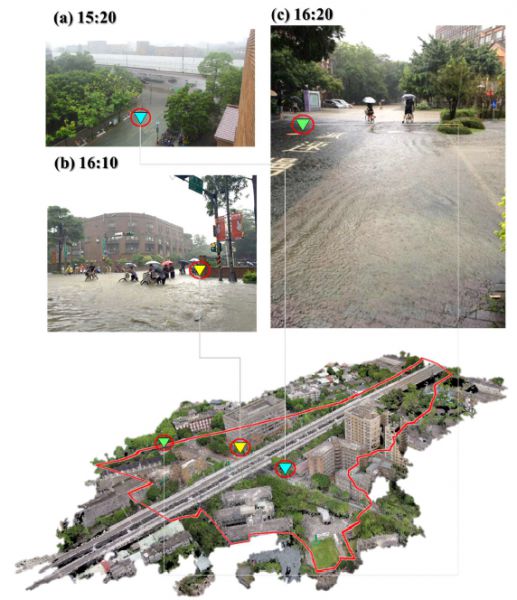
Figure. Image-based VGI illustrating photograph shooting locations and acquisition times of (a) 15:20, (b) 16:10, and (c) 16:20 through the point cloud.


