生態農業:農業地景生態監測及復育【水土保持學系/陳樹群特聘教授】
| 論文篇名 | 英文:A landslide ternary diagram for geometric form and topographic site in Taiwan 中文:台灣崩塌地之地理位置與幾何形狀的崩塌三角圖 |
| 期刊名稱 | LANDSLIDES |
| 發表年份,卷數,起迄頁數 | 2020, in press |
| 作者 | Tfwala, Samkele; Huang, Chia-Ling; Tsou, Ching-Ying; Chen, Su-Chin(陳樹群)* |
| DOI | 10.1007/s10346-020-01507-2 |
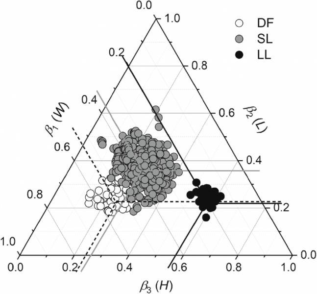
| 中文摘要 | 由於颱風和暴雨常常在台灣造成重大的崩塌災害,使得台灣近年來受降雨事件所引發的災害數量大幅增加。本研究中使用2006年至2014年受降雨影響而產生的崩塌災害數據(共605筆),並將其分為以下三類: 淺層崩塌(SL, 495筆)、大規模崩塌(LL, 34筆)、土石流(DF, 76筆)。大規模崩塌被定義為,面積大於10 ha、深度大於2 m、體積大於2*105 m3。研究中藉由三角圖分析其幾何形狀、地理位置分布、規模與體積特徵。研究結果發現,淺層崩塌的崩塌長度與體積具有明顯的線性關係,隨著崩塌長度的增加,其趨勢會逐漸減弱並收斂到與大規模崩塌相同。大規模崩塌的崩塌體積會與深度具有明顯的正相關。此外,淺層崩塌和土石流的平均長寬比非常相近,因此他們具有相似的型態。但是,淺層崩塌通常發生在坡腳附近;而大規模崩塌由於其體積較大,因此會由山脊附近開始並逐漸延伸往最近的河流。在邏輯回歸中,利用寬度(β1)、長度(β2)、深度(β3)作為崩塌的分類指數。研究發現β1是分類土石流、淺層崩塌、大規模崩塌的最佳模型,其正確率為0.955。儘管深度指數(β3)在綜合表現方面較差,但其在大規模崩塌的分類方面具有100%的正確率。 |
| 英文摘要 | The number of natural disasters induced by rainfall events in Taiwan has soared, with typhoons and torrential rains invariably inducing major landslides. In this study, data on major rainfall-generated landslides (605 in total) which occurred between 2006 and 2014 were used to classify landslides as types: shallow landslides (SL, 495), large landslides (LL, 34), and debris flows (DF, 76). LL were defined as landslides having an area, depth, and volume greater than 10 ha, 2 m and 2 °— 105 m3, respectively. These were then analysed for their geometric form, geographic distribution, and scale and volume characteristics through a ternary diagram. A significant linear trend was found between the length (L) and volume (V) of SL, with the trend gradually moderating and converging with LL as length increased. The volume of LL displayed a significant increasing trend with depth (H), while SL and DF had less depth and average distribution. The median landslide length/width (L/W) ratios of SL and LL were quite close, and they had relatively similar morphologies; however, SL tended to occur near the slope toe, while large LL, due to their large volume, originated near the mountain ridges and extended to the nearest streams. The power law scaling components of W (β1) and L (β2) of SL were similar because of their (SL) small size, and they were highly concentrated at the centre of the developed ternary diagram. Through logistic regression, we further validated the exponents in classifying the landslides; β1, β2, and β3 (power law scaling component of H) are used in the ternary diagram. Overall, β1 was found to be the best model for classifying DF, SL, and LL having a correct rate of 0.955 and a lowest Akaike information criterion (AIC), 136.115, and Bayesian information criterion (BIC), 153.736. β3, the depth index, though had a poor AIC, was 100% correct in classifying LL. |


