生態農業:農業地景生態監測及復育【土木工程學系/楊明德特聘教授】
| 論文篇名 | 英文:Geostatistical Based Models for the Spatial Adjustment of Radar Rainfall Data in Typhoon Events at a High-Elevation River Watershed 中文:可適於高海拔河流流域颱風之雷達降水地理統計模型 |
| 期刊名稱 | REMOTE SENSING |
| 發表年份,卷數,起迄頁數 | 2020, 12 (9),1427 |
| 作者 | Wang, Keh-Han; Chu, Ted; Yang, Ming-Der(楊明德)*; Chen, Ming-Cheng |
| DOI | 10.3390/rs12091427 |
| 中文摘要 | 地形限制了水位計的數量和位置,尤其是在高海拔山區,因此通常透過空間內插來估算未設站的降雨量。但是,站數不足在空間內插很容易造成總體降雨分佈的誤差。本研究開發兩種基多元回歸克利金(RK)和合併空間內插技術,,從不可靠的雷達估計值中調整雨場,以符合測站觀測值,並應用於台灣高海拔陳玉蘭河流域。本方法應用於過去12年襲擊台灣的5個中至高強度颱風事件,即Kalmaegi, Morakot, Fungwong, Sinlaku, 及 Fanapi,使QPESUMS雷達降雨數據可以得到準確校正。透過RK和合併空間內插技術對降雨量進行交叉驗證,並將其與普通克利金法(OK)的內插結果進行比較,包括三方面分析(誤差分析、降雨歷線和45度數據散佈圖)。從結果可以清楚地看出,RK和合空間內插技術都可以有效地產生覆蓋研究流域的可靠降雨數據。在流域內,均方根誤差(RMSE)最多可降低30%至40%,調整後降雨數據的平均效率係數(CE)也可以提高到0.84以上。總結而言,透過RK或合併空間內插技術可以更準確的校正原始QPESUMS降雨數據,優於單變量OK方法,特別是對於測站數量不足或相離甚遠的高海拔山區集水區。 |
| 英文摘要 | Geographical constraints limit the number and placement of gauges, especially in mountainous regions, so that rainfall values over the ungauged regions are generally estimated through spatial interpolation. However, spatial interpolation easily misses the representation of the overall rainfall distribution due to undersampling if the number of stations is insufficient. In this study, two algorithms based on the multivariate regression-kriging (RK) and merging spatial interpolation techniques were developed to adjust rain fields from unreliable radar estimates using gauge observations as target values for the high-elevation Chenyulan River watershed in Taiwan. The developed geostatistical models were applied to the events of five moderate to high magnitude typhoons, namely Kalmaegi, Morakot, Fungwong, Sinlaku, and Fanapi, that struck Taiwan in the past 12 years, such that the QPESUMS' (quantitative precipitation estimation and segregation using multiple sensors) radar rainfall data could be reasonably corrected with accuracy, especially when the sampling conditions were inadequate. The interpolated rainfall values by the RK and merging techniques were cross validated with the gauge measurements and compared to the interpolated results from the ordinary kriging (OK) method. The comparisons and performance evaluations were carried out and analyzed from three different aspects (error analysis, hyetographs, and data scattering plots along the 45-degree reference line). Based on the results, it was clearly shown that both of the RK and merging methods could effectively produce reliable rainfall data covering the study watershed. Both approaches could improve the event rainfall values, with the root-mean-square error (RMSE) reduced by up to roughly 30% to 40% at locations inside the watershed. The averaged coefficient of efficiency (CE) from the adjusted rainfall data could also be improved to the level of 0.84 or above. It was concluded that the original QPESUMS rainfall data through the process of RK or merging spatial interpolations could be corrected with better accuracy for most stations tested. According to the error analysis, relatively, the RK procedure, when applied to the five typhoon events, consistently made better adjustments on the original radar rainfall data than the merging method did for fitting to the gauge data. In addition, the RK and merging methods were demonstrated to outperform the univariate OK method for correcting the radar data, especially for the locations with the issues of having inadequate numbers of gauge stations around them or distant from each other. |
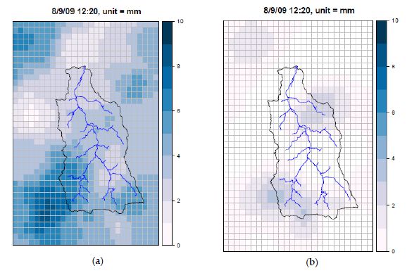
Figure (a) Sample plot showing a trend surface of the QPESUMS rainfall distribution, and (b) sample plot of the residual surface of rainfall variation, based on radar data from Typhoon Morakot in August 2009.


